
Announcing Project GYE: Yellowstone Without Borders
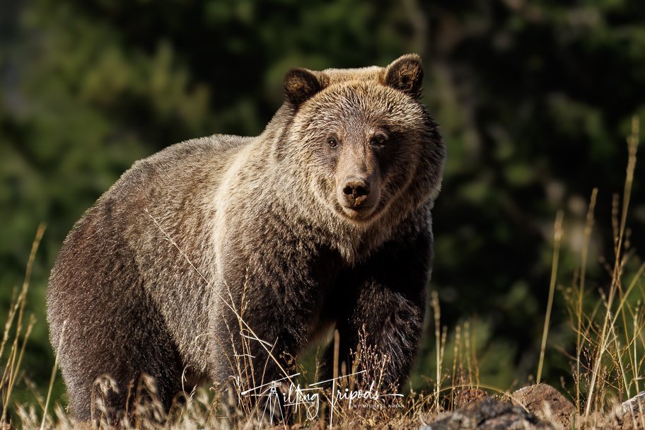
A Juvenile Male Grizzly spotted along Route 14 through the North Fork of Wyoming, Outside of Yellowstone National Park
We are pleased to announce our first project, Project GYE: Yellowstone Without Borders, focused on raising awareness of the Greater Yellowstone Ecosystem (GYE), in order to better protect it and the wildlife that resides within it.
The Greater Yellowstone Ecosystem (GYE) is a truly special place and is like nothing else in the lower 48. At roughly 34,375 square miles or 22 million acres, it is one of the largest nearly intact temperate-zone ecosystems on Earth. This is truly immense. To give you a better idea of its size, the state of Rhode Island on the other hand is 1,034 square miles, or 988,864 acres. So the GYE is roughly 22 times the size of the state of Rhode Island. That’s over 2 million acres larger than the state of South Carolina. Yellowstone National Park at just over 2.2M acres is larger than both Rhode Island and Delaware alone.
While Yellowstone and Grand Teton National Parks are well known, many fail to realize that the two famous parks are just the tip of the proverbial iceberg. While Yellowstone and Grant Teton are the centerpieces, they are surrounded by five national forests (Custer Gallatin National Forest, Beaverhead-Deerlodge National Forest, Caribou-Targhee National Forest, Bridger-Teton National Forest, and Shoshone National Forest) and three other federal areas protected by the US Fish and Wildlife Service (National Elk Refuge, Red Rock Lakes, and Grays Lake National Wildlife Refuge). Over 90% of the 22M acres within the GYE sit outside the borders of Yellowstone and Grand Teton and sit within a variety of private and public lands.
The primary goals of Project GYE: Yellowstone Without Borders:
Goal #1: Raise awareness of the Greater Yellowstone Ecosystem (GYE) so that others are able to better appreciate and enjoy the area and thus understand why we want to protect it.
Goal #2: Better protect the wildlife, specifically the bears and wolves, that venture outside the protected confines of Yellowstone and Grand Teton National Parks. A key aspect of that will be helping to better manage animal and human conflict.
The wildlife that reside within these parks can enjoy all of the protections that come with residence, they quickly lose these protections once they leave the confines of the two great parks. While we hope to protect all species, our primary focus will be on Grizzly and Black bears. Once nearly extinct, the GYE is now estimated to be home to a population of over 1000 grizzly bears. However, only an estimated 150-200 Grizzlies reside within the confines of Yellowstone National Park. This means that 800+ Grizzlies live without the protections that the Park provides. The GYE is also estimated to be home to between 500-1000 black bears. This is the largest population of bears, especially grizzly bears, anywhere in the lower 48 states. Not only is the broader GYE home to the majority of the Grizzly population, it is also where the chance of human and bear conflict is the highest.

Yellowstone National Park Rangers and Wildlife Management Resources protecting both the wildlife and crowds within the park. These same resources aren’t available outside of the parks.
“The Greater Yellowstone Ecosystem is one of our favorite places on the planet. It is a place that has provided us with a great deal of enjoyment, peace, and healing. “ said Michael Arian, co-founder of Tilting Tripods Wildlife. “Many of the species of wildlife that reside within the ecosystem, can’t be found anywhere else in the lower 48 states. It would be a travesty if we can’t find a way to co-exist.”
The goal of the project will be to use our photography, videos, and blogs, to share stories focused on the wildlife within the GYW but outside of the parks, especially where the opportunity for human and wildlife conflict is the highest. Phase 1 of the project in 2025 will focus on three core locations within the ecosystem:
The North Fork of the Shoshone River / East Entrance of Yellowstone National Park: Route 14 runs through Cody and into the East Gate of Yellowstone National Park, following the North Fork of the Shoshone River. This section of Route 14 that leads from the park through the high-rimmed red rock canyon walls is one of the first places on the East side of the park where wildlife and humans come together and reside together. Grizzly and Black bears, Elk, Bison, Mountain Goats and Big Horn Sheep, among other wildlife can be found along this stretch of roadway.
The Beartooth Highway: According to Wikipedia, “The Beartooth Highway is an All-American Road in the western United States on a section of U.S. Route 212 in Montana and Wyoming between Red Lodge and the Northeast entrance of Yellowstone National Park. It crests at Beartooth Pass in Wyoming at 10,947 feet (3,337 m) above sea level, and was called "the most beautiful drive in America," by late CBS News correspondent Charles Kuralt.[2] Because of heavy snowfall at the top, the pass is usually open for about five months per year, from mid-May to mid-October, weather conditions permitting.[3]” Along with being one of the most stunning stretches of roadway that we have ever driven, it is also home to a variety of wildlife across its many natural ecosystems. While mostly uninhabited, there are several areas of opportunity for human and animal conflict from the few habituated sections of the road such as Cooke City, MT, the close to twenty campgrounds, and the livestock that free range along the roadway.
The Sunlite Basin: Nestled along the Chief Joseph Highway, the Sunlite Basin sits about halfway between the Beartooth Highway and Route 120 where the Chief Joseph terminates. The Chief Joseph Scenic Highway runs through 47 miles of rugged Wyoming country, tracing the route that the Clark's Fork of the Yellowstone River carved through the basin. In the early 1800s, prospectors and fur traders trapped in dense fog in the mountains named the Sunlight Basin after the sudden sunlight-covered valley. According to them, "The only thing that can get into this valley most of the year, is sunlight."[3] Sunlight Creek, which flows east through the middle of the area from the mountains into the canyon, is named for the basin. While the area is still true wilderness, there are a small number of homesteads and ranches that spot the basin. You will frequently see free-range cows lining the section of roadway that runs through the basin.
We will be spending May 1 through the end of October of this year exploring these areas and will share our journey, stories, and findings across our Instagram, Facebook, YouTube Channel, and the Project GYE blog.